On 12 September seven technical workshops/tours will be organised to provide an experience of the “cities we have” in South Africa. It is a day to see actually how South African cities work and the very orderly, dynamic and creative processes which animate them. The workshops are organised such that they cover at least two or more of the conference themes. They also provide an experience of the diverse South African environments in terms of rural, urban, industrial, informal, suburban and oceanic locations.
Congress Participants are expected to choose one of the seven workshops.
There is a limit for each Technical Workshop of 50 participants. First come, first served base.
Tours 3 and 5 leave at 7.30 from the ICC.
All other tours leave at 8.00 from the ICC.
Shuttles will leave the Congress official hotels at 07:00 and 07:30 respectively to the Durban ICC.
| Area of Technical Workshop | Project(s) |
| 1. City of eThekwini | Inner City Development |
| 2. City of eThekwini | Peri-urban development |
| 3. Umhlathuze Municipality | Richards Bay Steel Bridge, Empangeni and uMzingwenya Settlement |
| 4. KwaDukuza Municipality | Southern region EThembeni Precinct Groutville Rocky Park Integrated Housing Project |
| 5. Ray Nkonyeni Municipality (previously known as Hibiscus Coast Municipality) | Alamein Avenue Precinct; Margate Airport MP; Oatlands Landfill Site |
| 6. Msunduzi Municipality | Greater Edendale and Vulindlela Development Area |
| 7. EThekwini Municipality | Dube Tradeport / King Shaka International Airport |
Short Descriptions of the Technical Workshops – for detailed description see below
 Technical Workshop One: Inner City Tour
Local-Co-rapporteur: Zinzile Mbinza, University of Johannesburg

eThekwini Metropolitan Municipality is the largest City in this province and the third largest city in the country. It is a sophisticated cosmopolitan city of over 3 442 398 people (as per 2011 Census). It is known as the home of Africa’s best-managed, busiest port and is also a major centre of tourism. Its land area of 2,297 square km is comparatively larger than other South African cities.
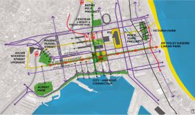
This workshop consists of three sites. The first site will take delegates through the Inner- City. The tour will start at the Warwick walk on Grey Street and turn to Anton Lembede down to the City Hall and have entertainment at the City Hall Park.
The second part of the tour involves meeting at the City Hall and walking across the Gugu Dlamini Park to the centrum sites to view the government precinct and the future of the centrum and how it fits into a current function of the city. The delegates will then walk across to the ICC through KE Masinga Street and get to the beach front to experience the promenade. This is a shared space where social integration, active and vibrant city will be discussed (the city we need).
The third part of the tour will start at the city hall with a walk toward the Marina (Victoria Embankment), to Wilson Wharf, and stop at the Bat Centre for Music and fine dining. The walk will carry on towards the Ushaka Marine and Point Waterfront where delegates will have a presentation on the future plans of the Point Waterfront, Beach Front upgrade and future expansion of the promenade.
 Technical Workshop Two: Peri-urban Development
Local Co-rapporteur: Lize Barclay, Western Cape Government
 The delegation will drive off Umgababa to join the N2 north and take the next off ramp to the R603 to Adams/Folweni (greater Umbumbulu areas) to view non-formal peri-urban development along the R603 to explore houses that are formal in nature but do not conform to any planning standards. The last stop will be at the Umbumbulu Town Centre where the team will be appraising delegates with the progress to date on developments for formalising Umbumbulu as rural Service Node.
The delegation will then drive back via the Inwabi Road and join the Mangosuthu High Way (M30). This route will take the delegation through to the Umlazi Township to explore R293 township experience and transition in services that are provided for different areas from rural, peri-urban settlements, townships and suburban areas. The Umlazi Township also has number of planning challenges which are slightly different than the per-urban. It has high density informal settlements located on inaccessible areas as well as in areas that are prone to environmental disasters.
Finally the tour will go through the nodal structure that the city has developed to promote local economic development and integration of spatial segregated sections in the township such as the KwaMnyandu and Mega City shopping Malls. The delegation will then visit one of the townships dining area to experience African cousins at the Maxis life Style.
 Technical Workshop Three: uMhlathuze Municipality
Local Co-rapporteur: George Onatu, University of Johannesburg
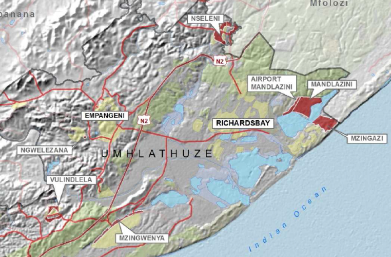
uMhlathuze Local Municipality is an administrative area in the King Cetswayo (former uThungulu) District of KwaZulu-Natal. The municipality is named after the Mhlatuze River and is situated on the north-east coast of the province of KwaZulu-Natal about 150 kilometres north-east of Durban. The municipality borders a coastline that spans approximately 45 kilometers.
There are a number of natural and man-made phenomena that have shaped and continue to shape the uMhlathuze Municipality. The area is inundated with a system of wetlands and natural water features such as Lakes Cubhu, Mzingazi, Nsezi and Nhlabane. Major rivers include the Mhlathuze and Nsezi. The municipal also includes the formal towns of Empangeni, Richards Bay, eSikhaleni, Ngwelezane, eNseleni, Vulindlela and Felixton as well as the traditional authority areas under Amakhosi Dube, Mkhwanazi, Khoza, Mbuyazi and Zungu. Apart from the areas of natural significance, large tracts of land are under commercial agricultural production.
This workshop has three study focus areas which provide a mix of all the themes of the conference.
Study area one entails a visit to the Richards Bay Steel Bridge for which a conceptual redesign was completed. The Richards Bay Steel Bridge is located at the ‘gateway’ of the Richards Bay Waterfront and spans over the Mzingazi canal. The prime location of the Richards Bay Waterfront attracts a diverse range of users that evokes a proud sense of place and culture in the region. The Richards Bay Waterfront accommodates a small craft harbour, where luxurious ocean yachts dock, an upmarket office complex, numerous shops, pubs, restaurants, luxurious accommodation and walk on moorings in this precinct all add to the vibrant atmosphere of the area.
The overall intention of the project was to lay the proverbial foundation for the development of an iconic bridge structure, in order for the area to reach its full potential.
Study area two focuses on Empangeni town and specifically its CBD which has evolved naturally over time into a functional town that serves the community in the hinterland. However, town planning intervention is needed to improve the functionality and long term issues of sustainability of the CBD.
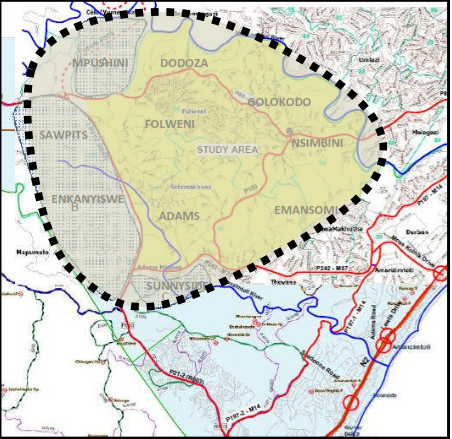
Study area three is the uMzingwenya Settlement. This settlement borders the R293 Township of Esikhaleni. It is located between the Main Road (Mdlebe Ntshona) to the east and the Mzingwenya River to the west. There is a major Eskom power line that passes through the settlement that has a 35M servitude. The settlement has developed over the last 30 years. Some of the land is allocated by the Traditional Authority and in some instances by local landlords operate without consideration of environmental and service installation issues.
The uMzingwenya area has been earmarked as a Restructuring Zone by the uMhlathuze Municipality with the support of the National Upgrade Support Programme (NUSP) which is run by the National Department of Human Settlements. Restructuring zones are intended to serve as an instrument (among others) to pursue restructuring of South African cities. The restructuring is largely about moving away from housing interventions that further entrench segregation and buttress social and economic disparities.
 Technical Workshop Four: KwaDukuza Local Municipality
Local Co-rapporteur: Kenneth Newman, Cape Peninsula University of Technology
 KwaDukuza Local Municipality is a municipality in the iLembe District Municipality, KwaZulu-Natal, South Africa. KwaDukuza was previously known as Stanger which is the home town to King Shaka’s memorial monument. KwaDukuza has a vibrant central business district with a distinct Eastern cousin flavour catering for visitors and locals alike.
This workshop has four study areas which provide a mix of all the themes of the conference. Study area one consists of the Southern region of KwaDukuza Local Municipality. It is located within an “Aerotropolis” or “Airport city” which has the King Shaka International Airport as its nucleus. It is also located within the eThekwini-uMhlathuze corridor which is the Primary Provincial corridor in terms of the Provincial Growth and Development Plan.
Study area two is the EThembeni Precinct Plan/Township Establishment Project. It is located between the towns of Shakaskraal to the south and KwaDukuza to the north. This area includes land parcels that were transferred from the Department of Land Affairs to private owners. This is an emerging peri-urban settlement that is experiencing rapid development without any formal development application approval or disposal of sites by the original land owners. Added to this situation, is the fact that a large portion (+-73%) of this area is considered to be a wetland.
Study area three focuses on Groutville which is located approximately 4 km south of the KwaDukuza Town. This project entails an upgrading of an existing informal settlement which has both formal and informal structures. There are housing structures that are located on wetlands and environmentally sensitive areas. The project grapples with the challenge of maintaining a balance between the provision of infrastructure and sustaining existing location of houses.
Study area four is called the Rocky Park Integrated Housing Project. It is located on the western periphery of the KwaDukuza CBD. This is a mixed use development comprising of community residential units, affordable units, and lower income units with associated service infrastructure and social amenities. It is a groundbreaking project as it integrates a range of income levels and accommodates different forms of housing opportunities.
 Technical Workshop Five: Ray Nkonyeni Municipality (previously known as Hibiscus Coast Municipality)
Local Co-rapporteur: Matthew Dayomi, University of Kwazulu-Natal
Ray Nkonyeni Local Municipality is the economic hub of the Ugu District Municipality in the KwaZulu-Natal Province. The coastline is dotted with small towns, many of which serve as seasonal recreational hubs, such as Port Shepstone, Umtamvuna / Port Edward, Margate, Hibberdene and Impenjati / Southbroom. These towns feature a wide range of tourist-oriented businesses, including restaurants, bars, clubs, movie houses, golf courses, clothing shops, museums, and various types of accommodations. A range of beaches are world-class quality are found along the entire seaboard. Hibberdene Beach, Ramsgate Beach, Marina Beach/San Lameer, and Lucien Beach have been recognized as Blue Flag beaches. The area therefore attracts tourists from KwaZulu-Natal and other provinces as well as international tourists.
Ray Nkonyeni Municipality has identified three areas to form part of this Technical Workshop. These are the Alamein Avenue Precinct, the Margate Airport Master Plan, and the Oatlands Landfill Site. The Alamein Avenue Precinct project area falls within two wards i.e. Wards 3 and 19. It falls mostly within the Uvongo Area which is a relatively small town with a population of approximately 5 804 (ward 19) and 8 531 (ward 3). The study area is a small but significant area which is located in the southern section of the municipality. It is made up of two settlements i.e. Uvongo town and Masinenge Informal Settlement. Currently, there is a spatial divide between the two settlements which emerged from land needs and access to urban opportunities which has resulted in crime, high pedestrian traffic from the informal settlement into the Uvongo town; vehicle traffic congestion; dilapidation of road infrastructure; etc.
The second area is the Margate Airport Master Plan. The Municipality is experiencing unprecedented economic growth. For a town to attract and retain co-operations with regional and national ties, an efficient and functional airport that can be easily reached is important. Airports are vital gateways to places and can give effect to stimulating commerce and local economies
Margate Airport holds such potential and is one of the airports identified by the Provincial KZN Regional Airport Strategy which aims to use regional airports to grow the economy of regional towns in both aeronautical and non-aeronautical developments.
The proposed Margate Airport Master Plan presents an opportunity for development of an “aero-park’’ and integrated ‘non-aeronautical’ and aeronautical avenues to improve sustainability in its broad spectrum. An opportunity also exists to create sustainable and viable schemes by carefully integrating airports with their surrounding commercial precincts in order to unlock the catalyst effect of airports on economic growth and development.
The third site is the Oatlands Landfill Site. The Oatlands landfill site is located within the jurisdiction of the Ray Nkonyeni Municipality. The landfill site was developed on behalf of the Region by the Ugu District Municipality prior 1994. The Ray Nkonyeni Municipality took over the operation of the site in 1994. The Oatlands landfill site is part of the service delivery vehicles used by the Municipality to fulfil the constitutional mandate contained in Section 24 of the Constitution of the Republic of South Africa, 1996 (Act 108 of 1996).
Oatlands landfill site is a Class B site recently licensed by the Department of Economic Development Tourism and Environment Affairs (EDTEA). The landfill site is a resource for the Ray Nkonyeni Municipality and the Ezingoleni Local Municipality which will be amalgamated after the Municipal elections on the 3rd August 2016. It should be further noted that the Eastern Cape partially makes use of the site.
The site receives approximately 35 000 tons of Municipal Solid waste collected by Municipal vehicles and private vehicles annually. The site has an estimated 25 years airspace potential. The site has a further potential of becoming a regional site. The disposal of waste is an essential service to the community; currently disposal airspace is available for a maximum of 1 year.
 Technical Workshop Six: Msunduzi Municipality
Local Co-rapporteur: Selna Cornelius, University of North West

Msunduzi Local Municipality is a local municipality in Umgungundlovu District Municipality, KwaZulu-Natal. It is situated on the N3 highway at a junction of an industrial corridor (from Durban to Pietermaritzburg) and an agro-industrial corridor (stretching from Pietermaritzburg to Estcourt). It encompasses the city of Pietermaritzburg which is the capital of the KwaZulu-Natal province and the main economic hub of the district. The Municipality is regarded as the second largest urban centre within KwaZulu-Natal. Its location has a strong influence on the regional channels of investment, movement and structuring of the Provincial spatial framework for growth and development.
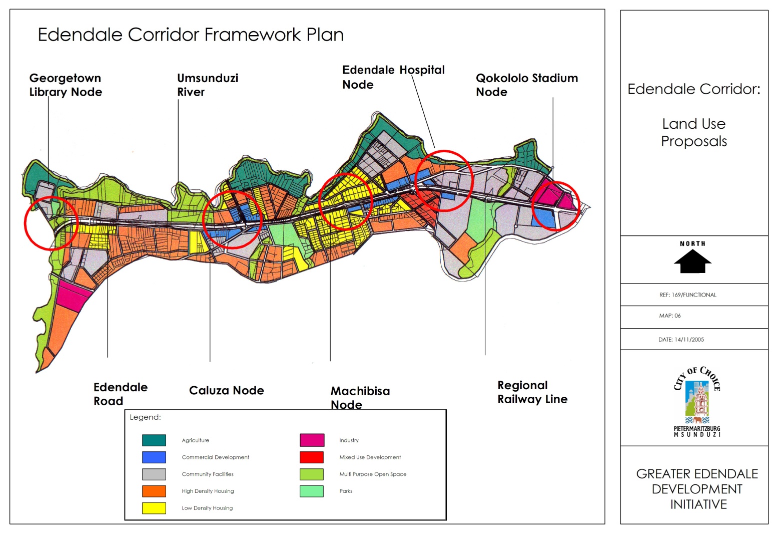
This workshop has two study areas namely Greater Edendale and Vulindlela Development which provide a mix of all the themes of the conference. The two areas bring into focus the ability of the Greater Edendale and Vulindlela Development Initiative (GEVDI) to deliver on its mandate i.e. a developmental local government tasked with attacking the blight of poverty, exclusion and deprivation.
The Greater Edendale Area was established as a Section 30 Town, as per the Black Administration Act 38 of 1927, by the former Department of Development Aid and now forms part of the present Msunduzi Municipality. It was the subject of a macro planning analysis and was divided into 18 Functional Areas. Broad brush plans were prepared for each Functional Area detailing the role, character, spatial features as well as key development interventions that were required in order for the functional Areas to reach basic performance levels. Vulindlela is a rural area, 136km from Pietermaritzburg with a population of 560039 and an area of 9.81 km².
GEVDI provides a perspective that is linked to a continuous process of spatial transformation [restructuring of the city landscape] wherein substantial room for creativity is allowed both in development, planning and decision making. It promotes the establishment of a hierarchy of mixed use Service Nodes at key intersections along the corridor to accommodate commercial, community and public transportation facilities.
 Technical Workshop 7: EThekwini Municipality – Dube Tradeport / King Shaka International Airport
Local Co-rapporteur: Yandisa Mashalaba, University of Free State
 The eThekwini Municipality is located on the east coast of South Africa in the Province of KwaZulu- Natal (KZN) and is bordered by three district municipalities, namely, iLembe in the north, UGu in the south and uMgungundlovu in the west. The eThekwini Municipal Area spans an area of approximately 2297km2, extending from Tongaat in the North to Umkomaas in the South and from the coastline in the East to Cato Ridge in the West and is characterized by coastal plains and steep and dissected topography.
As part of the Municipal planning process and system, the Municipal area has been divided into four functional areas. The Northern Municipal Planning Region (NMPR) stretches from the northern banks of the Umgeni River in the South up to and including Tongaat in the North, from the coast line in the east to UMzinyathi, Inanda and border with the ILembe District Municipality in the West and North.
Future economic and residential growth in the North of eThekwini has been planned for around the Dube Trade Port; however it is also critical that growth anticipates and align with the needs of the city’s immediate municipal neighbours to the north; Ndwedwe and KwaDukuza.
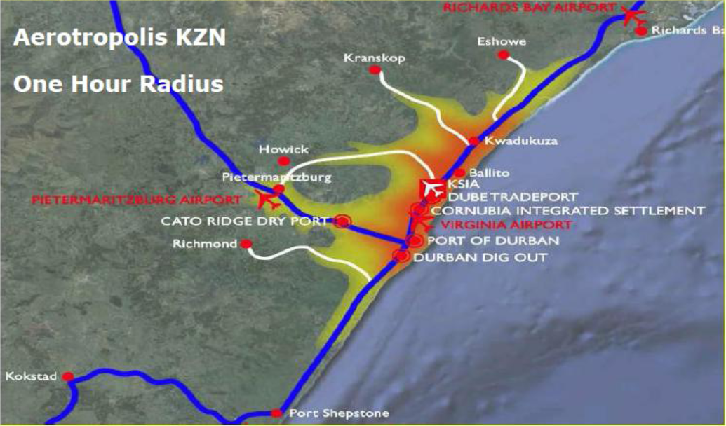
The King Shaka International Airport (KSIA)/Dube TradePort , is located approximately 30 kilometers north of Durban in South Africa. The development presents a greenfields opportunity to promote a highly efficient integration of airport and airfreight infrastructure, supported by complementary, world class logistics platform with high value agricultural, manufacturing and business services zones.
This technical workshop will locate the Dube TradePort development within a global, national, provincial and local context, and reflects on the strengths and opportunities the project presents. The challenges that need to be addressed in planning for airport related development, termed as Airport Cities or Aerotropolis, within a developing world context will be identified. These will be discussed with a view to informing further interventions in the airport region.
The typical planning challenges include the demand for land in the aerotropolis region which is largely driven by international connectivity. Estimating future connectivity or changes within global patterns of air traffic is challenging, and planning frameworks need to be flexible enough to accommodate for change. Another is the provision of new bulk infrastructure in order to improve the overall efficiencies and reduce the cost of logistics. Consideration for locating residential uses outside of the 55LRdn noise contour extends the spatial extent of the aerotropolis area. The tension between retaining sufficient space for future phasing and growth and at the same time promoting a compact urban form requires careful planning, particularly around public transport. The real challenge is to integrate the airport led development into city development, so that investment reinforces a functional, well performing place.
Dealing with environmental issues within the context of aerotropolis development is another challenge. Policy choices being made at local government level that may have a significant impact on national and provincial infrastructure. Part of the problem arises from the fact that this is the first airport of this scale to be built in South Africa in the last 60 years and where the position of airports in a global context has fundamentally changed in recent years. The lack of previous experience or examples relating to aerotropolis planning in South Africa makes the task all the more daunting. A final challenge for planning the aerotropolis region relates to a tension evident in most planning processes. Achieving the most equitable distribution of resources possible, and ensuring that the benefit from this investment does not only accrue to private developers and the airport operation, is an important challenge.
Detailed Description of Tours
Technical Workshop 1 – eThekwini (Inner-city)
Technical Workshop 2 – eThekwini (Peri-Urban)
Technical Workshop 3 – City of uMhlathuze
Technical Workshop 4 – KwaDukuza Municipality
Technical Workshop 5 – Ray Nkonyeni Municipality (Previously HCM)
Technical Workshop 6 – Msunduzi Municipality
Technical Workshop 7 – eThekwini (Dube Tradeport)